
Resilience and Adaptation to Drylands
Identifying past water management practices for drought-resistant crops
The methodology developed will be applied to archaeobotanical material from three case-study sites located in biophysical hotspots in Asia and in sub-Saharan drylands.
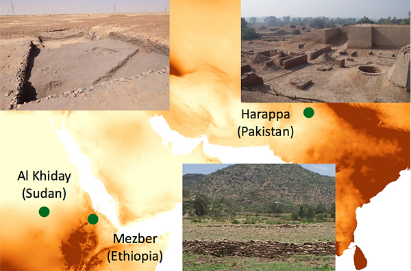
1. Harappa (Pakistan).
Harappa lies in the vicinity of a large perennial river, the Ravi, which was the most-likely source of water for the crops grown around the city (décrue). Scholars have suggested that some form of irrigation was necessary to grow sufficient crops to sustain the city’s population, although this has recently been contested. RAINDROPS will test this hypothesis and clarify the possible existence of both water management practices. Harappa is one of the main centres of the Indus Civilisation, which developed in what are now modern India and Pakistan during the 3rd and 2nd millennia BC (3300-1700 BCE). The site has been excavated for over 30 years and new excavations are due to begin next year. Several archaeobotanical studies have been conducted on material from the site, including charcoal studies as part of my PhD dissertation work . The archaeobotanical work has highlighted the presence of several different C3 and C4 crops, including millets
2. Al Khiday (Sudan).
This cluster of sites in Central Sudan is positioned not far form the modern banks of the White Nile, suggesting that floods were a likely source of water for cultivation (décrue). However, ethnoarchaeological fieldwork at Al Khiday has revealed the presence of historical and current rain-fed agricultural fields further inland from the Nile (over 50 km). This makes Al Khiday an important potential test case for the assessment of prehistoric rain-fed cultivation practises. Al Khiday comprises several occupations, including a cemetery and domestic contexts spanning from the Mesolithic to the Meroitic period (ca. 7000 BCE –100 CE). Previous isotopic analyses showed the presence and continuous consumption of C4 plants at the site, and the modern instances of rain-fed agriculture observed here are all related to sorghum. RAINDROPS will constitute one of the first comprehensive studies of botanical micro-remains for this area and time-period, and will collect important ethnographic data on rain-fed agriculture in deserts.
3. Mezber (Ethiopia).
The site is located far from a river system and related flood plains, or apparent irrigation structures. There is good reason therefore to hypothesise that the agriculture was driven by rainfall. The presence of dry-land agriculture based on ox plough and mixed annual crop has been suggested by the mid-first millennium BC. Evidences of water storage structures are present in the area (e.g. at Aksum itself) but are of much later chronology suggesting that most of the highland farming must have thrived without the support of irrigation. Occupied by an agro-pastoral society, the archaeological site of Mezber has a long frequentation that spans four cultural phases, from prehistoric to early Aksumite (1600BCE - 125 CE). The site is located in the region of North East Tigrai, an area that saw the emergence of complex societies during the second millennium BCE, leading to the formation of the Aksumite kingdom in the first millennium CE. Notwithstanding an early adoption of Near Eastern crops and animals, isotopic analyses on human skeletons suggest that people at Mezber consumed predominantly C4 plants. Preliminary micro-botanical analyses (phytoliths and starch) on grinding stones from pre-Aksumite levels have shown the important use of millets, including finger millet and sorghum.